Making the GR20 in 5 days

To complete this trail within these deadlines, you will leave with a lighter bag and a smaller list of equipment. You will have to rely on shelters to refuel. Here is an example of cutting to make the GR20 in 5 days.

Profile stages 17

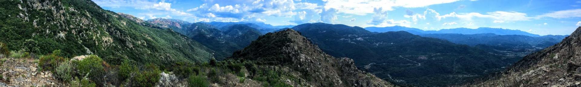
A result of a step per day, you put 16 days to make the GR20. This hiking trail between Conca and Calenzana you will discover the Corsican mountains from different angles: rocky terrain (dry and very technical in the north) but also parts greener and rolling (in the south).

Depending on the season, you may have to face the harshness of a day of walking in the sun, storms and fog or the freshness of a shower water source. But this is only a small price to pay for you marvel at the sunsets, stunning views of the sea, the passages of ridges and collars etc.. Small price to pay just to spend an unforgettable holiday.

It is advisable to make the GR20 before June because the shelters are not kept and trails may still be snow in places. It is not recommended to do so even after the end of August because some sources may be tarries.

Refuges 22

Calenzana to Ortu di u Piobbu

This is the first stage of the GR20. The distance is 12km (7.5 miles) Total ascent 1550m. Total descent 235m. Effective walking time 7hrs.

Ortu di u Piobbu to Carrozzu

Stage two of the GR20. The distance is 8km (5miles) Total ascent 750m. Total descent 1050m. Effective walking time 6h30.

Carrozzu to Haut Asco

Stage three of the GR20. The distance is 6km (3.75 miles) Total ascent 860m. Total descent 710m. Effective walking time 5h30hrs.

Haut Asco to Vallone

Stage four of the GR20. The distance is 9km (5.5 miles) Total ascent 1250m. Total descent 1230m. Effective walking time 9h30.

Vallone to Ciottulu di Mori

Stage five of the GR20. The distance is 15km (9.5 miles) Total ascent 850m. Total descent 870m. Effective walking time 6hrs.

Ciottulu di i Mori to Manganu

Stage six of the GR20. The distance is 25km. Total ascent 650m. Total descent 1050m. Effective walking time 9hrs.

Manganu to Petra Piana

Stage seven of the GR20. The distance is 17km (10.5 miles) Total ascent 670m. Total descent 475m. Effective walking time 6hrs.

L'Onda to Vizzavona

Stage nine of the GR20. The distance is 13km (8 miles) Total ascent 990m. Total descent 1500m. Effective walking time 7h30.

Vizzavona to Capanelle

Stage ten of the GR20. The distance is 16km (10 miles) Total ascent 1000m. Total descent 335m. Effective walking time 5h30.

Capanelle to Col de Verde

Stage eleven of the GR20. The distance is 14km (8.75 miles) Total ascent 320m. Total descent 620m. Effective walking time 4h30.

Col de Verde to Usciolu

Stage twelve of the GR20. The distance is 16km (10 miles) Total ascent 1290m. Total descent 830m. Effective walking time 7h30.

Usciolu to Crocce

Stage thirteen of the GR20. The distance is 14km (8.75 miles) Total ascent 340m. Total descent 640m. Effective walking time 5h30.

Crocce to Asinau

Stage fourteen of the GR20. The distance is 9km (5.5 miles) Total ascent 665m. Total descent 545m. Effective walking time 4h00.

Asinau to Bavella

Stage fifteen of the GR20. The distance is 8km (5miles) Total ascent (550m). Total descent 865m. Effective walking time 4h15.

Bavella to Conca

Stage sixteen of the GR20. The distance is 19km (11.8 miles). Total ascent (700m) Total descent is 1670m. Effective walking time 7hrs.

Ortu di u Piobbiu Refuge

Alt 1520m. This is the first accommodation you will come across on the GR20 north when setting out from Calenzana.

Haut Asco Refuge, Hotel, Gite

Alt 1422m. This is the third accommodation you will come across on the GR20 north when setting out from Calenzana.

Tighjettu Refuge

Tighjettu 1683m is the fourth refuge you will come across on the GR20 north when setting out from Calenzana.

Ciottulu Refuge

Alt 1991m altitude. This is the sixth accommodation you will come across on the GR20 north when setting out from Calenzana.

Manganu Refuge

Alt 1600m. This is the ninth park refuge that you will come to on the GR20 north when setting out from Calenzana.

Petra Piana Refuge

Alt 1842m. This is the tenth park refuge that you will come to on the GR20 north when setting out from Calenzana.

Onda Refuge

Alt 1422m. This is the eleventh park refuge that you will come to on the GR20 north when setting out from Calenzana.

Vizzavona

This is the twelth step that you will come to on the GR20 north when setting out from Calenzana.

Capanelle

Alt 1586m. This is a private gite and camping area is enthusiastically managed by Roger Philippe and Laure Maurizi they are a brother and sister team.

Prati Refuge

Alt 1820m. This is the fifteenth accommodation that you will come to on the GR20 when setting out from Calenzana.

Col de Verde

Alt 1289m. This is the fourteenth accommodation that you will come to on the GR20 when setting out from Calenzana. It is a private gite, that has road access.

Usciolu Refuge

Alt 1750m. This is the sixteenth accommodation that you will come to on the GR20 when setting out from Calenzana.

Croci

Alt 155Om. This is the seventeenth accommodation along the way when setting out from Calenzana.

Col de Bavella

Alt 1218m. This is the nineteenth accommodation that you will come to on the GR20 when setting out from Calenzana.

Paliri Refuge

Alt 1055m. This is the last one on the trail GR20 !

Asinau Refuge

Alt 1400m. This is the eighteenth accommodation that you will come to on the GR20 when setting out from Calenzana.

Carrozzu Refuge

Alt 1270m. This is the second refuge on the GR20 north when setting out from Calenzana.

Vallone

Alt 1423m. This is the fifth accommodation that you will come to on the GR20 when setting out from Calenzana.

Is the GR20 for you?

The GR20 is certainly one of the hardest long distance walks out there. Several factors contribute to this, the rough rocky terrain, the unpredictable weather and micro climates.

The Spasimata Swing Brigde

The Spasimata swing bridge is a beauty spot. This big bouncy bridge takes you across the Spasimata river. The slabs of granite lead into a stunning enclosed ravine as the GR20 makes its way towards the Muvrella mountain.

Cascades des Anglais

The Cascades des Anglais is a series of rock pools and chutes of water that make up the river l’Agnone.

Lac de Nino

The Lac de Nino lake is situated between Castel di Vergio hotel and Manganu refuge. It is the source of the Tavignano river, situated between Castel di Vergio hotel and Manganu refuge, it has a surface area of 6.5 ha.

Breche de Capitello

The Breche de Capitello is a high mountain pass, situated at 2200m. It is a spectacular view point and can be snowed in early June.

The Monte Cinto

The Monte Cinto is the highest summit on the island, it is 2706m alt. It is accessible from both the Niolu valley and Haut Asco.

Electricity on the GR20

How about electricity on the GR20?

How much does it cost?

How to calculate the price for your GR20, how much does it all cost, the refuges, the food, a coffee...

Authorised or not on the GR20

The GR20 is protected by the Parc Naturel Régional de Corse. With such a large volume of people every year, there are certain rules in place to protect the area.

In which direction?

In Which Direction. North to South, or South to North.

Shoes on the GR20

The single most important equipment choice you make before leaving has got to be the choice of shoes.

Equipment

List of equipment to bring to do GR20.

State of the Refuges

The stone base layer, is what exists today of Carrozzu refuge. The above floor is the proposed design for the modernization.

IphiGénie and maps

The best maps of the route are produced by the IGN (Institut Géographique National) at a scale of 1:25,000.